Community Map Builder
Empowering communities to build and share geographic maps..
Home About Design Development
Community Map BuilderEmpowering communities to build and share geographic maps.. Home About Design Development |
 |
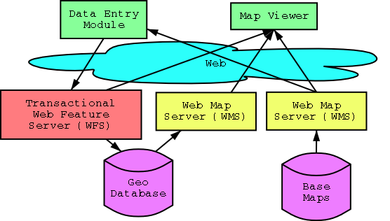
The Community Map Builder is a framework with inter-changable components which conform to Open GIS Standards. The aim is to build up a full set of Open Source components, and then develop the business logic to drive them.

This module will show a basemap, and allow a user to build a map feature (like a bike track), give it attributes, and save it to the server.
This module should be simple to use so that many people will use it. Ie, it should run in a web browser.
Currently, work in underway to enhance the geotools java applet to provide the required functionality for this. It is open source under the LGPL. See http//geotools.sourceforge.net
With lots of people maintaining the same database, we are going to need to develop updating rules. For example, if someone enters a bike path down the center of a multilane freeway, who should be allowed to remove the entry?
For these rules we should allow users to moderate each other as has been done very successfully with some news and comment sites like http://slashdot.org.
This will be a server which receives update requests and updates a geographic database. It will be designed according to the Transactional Web Feature Server specification from the Open GIS Consortium - http://opengis.org. At the time of writing, this spec was in draft form and has not been released publicly, however there are people working on this project who are members of the Open GIS Consortium who have access to this document.
There are a few open source technologies which are looking promising in this direction.
This is all that an end user will require to view the created maps. The end user will only need a web browser to view the created maps.
There are a few open source technologies available:
This is generally how basemaps will be served to the web. The specifications for the WMS are specified out by the Open GIS Consortium. It may also be how the maps created by the Community Map Builder are served to the web.
Mapserv - http://mapserver.gis.umn.edu provides a good open source WMS.
There are already numourous maps being served to the web using WMS protocols. With a bit of luck, you will be able to find one which will be useful for your Map Builder application.
All communications between components of the Community Map Builder will use Open GIS Standards. This means that any component or basemap can be replace with another when required.
|
Development Env |
Applet Map Viewer |
mapserv Web Map Server & Viewer |
FreeFS Web Feature Server |
PostGIS GIS Database |